How To Contact Us:
Brandon McMullen, Planning Director
111 West Washington St.
Burns, OR 97720
Phone: 541-573-6655
Email: brandon.mcmullen@harneycountyor.gov
Planning Commission
ORS 215.020-.030 outlines the authority and various guidelines for a Planning Commission.
|
Name |
Term Expires |
Region/Area |
| Rhonda Karges |
6/30/2028 |
Burns/Hines |
| Vern Brown (Chair) | 6/30/2030 |
Airport/Harney Valley |
| Barba Arnold | 6/30/2027 |
Drewsey |
| Sam Rawlins | 6/30/2030 |
Riley |
| Vacant |
|
|
| Norm Clark | 6/30/2027 |
Drewsey/Pine Crk |
| Wayne Evans | 6/30/2026 |
Riley |
The Planning Commission typically meets every 3rd Wednesday of the month.
Contact Planning Department for meeting dates.
The Oregon Revised Statutes that deal primarily with Planning Issues are ORS 92, 197, 215, etc.
The State-Wide Planning Goals are the driving force behind Oregon’s Land Use Laws.
The Oregon Administrative Rules provides greater direction as the Oregon Revised Statues are taken and put into a more usable format.
Land Use & Zoning Program
Planning Documents
Land Use-Goals, Policies, Regulations, & Procedures
The documents listed below provide the goals, policies, formal regulations and implementation procedures dealing with land use in Harney County.
Zoning Maps: Available online line from Harney County GIS.
Land Use Permit Fees:
Harney County Planning Department Fees
Land Use Permit Application:
The Land Use Permit Application provides one consolidated application for all types of land use permits available in Harney County. Many times only one application is needed to apply for multiple permits.
- Conditional Use Permit
- Farm Dwelling
- Non Farm Dwelling
- Partition
- Partition with Non-Farm Dwelling Application
- Lot of Record Dwelling Application
- Property Line Adjustment
- Variance Application
- Replacement Dwelling Application
- Goal Exception & Zone Change Application
- Tax Lot Consolidation Form
- Notice of Appeal Form
Harney County Comprehensive Plan
Harney County Subdivision and Partitioning Ordinance: The Subdivision and Partitioning Ordinance provides the regulations regarding the division of land and the development of multiple lots for residential purposes.
Harney County Zoning Ordinance: The Harney County Zoning Ordinance provides the legal framework for the land use regulations in the County. Each zoning designation and the specific provisions are listed here as well as maps for each zoning designation. These maps can be obtained electronically from the Planning Department.
Zoning Maps, not all maps that are in the Zoning Ordinance are included here. The list is complete the the only maps available will be linked to a PDF file. Printed maps are available and can be sent to you for a nominal fee Go to Preprinted Maps.
Harney County Inventories (i.e. Aggregate, Historic, Natural Areas, etc.) There are a number of inventories that have been put together in response to various Statewide Planning Goals.
HC Transportation System Plan 2001 (TSP)
The Harney County Transportation Plan was adopted in 2001 and provides the details for transportation and its development. The process for completing the TSP was valuable and the information, inventories and recommendations have proven to be a great benefit to the County.
Planning Department
Welcome to the Harney County Planning Department! Most all of the land use applications, building permits and other documents we use are listed here for download, printing or reviewing right online.
Current Events: None at this time.
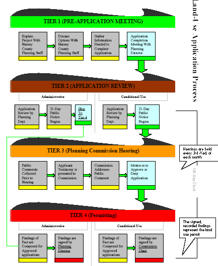
Land Use Application Flow Chart:
The process involved with making land use applications under Oregon Land Use Laws and the subsequent County Comprehensive Plan can be difficult to understand so the Planning Department has developed the convenient Land Use Application Flow Chart replicated below. Follow the link to access a full size version.